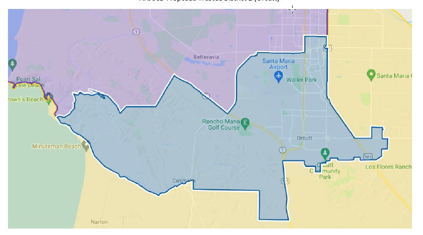
Area 2

Trustee Area 2
All of that portion of Santa Barbara County bounded and described as follows: Beginning at the point of intersection of Combar Rd and Point Sal Rd, and proceeding easterly along Combar Rd to unnamed Vehicular trail, and proceeding easterly along unnamed Vehicular trail to nonvisible boundary, and proceeding easterly along nonvisible boundary to Cabrillo Hwy, and proceeding easterly along Cabrillo Hwy to Black Rd, and proceeding northerly along Black Rd to the Santa Maria city line, and proceeding northerly along the Santa Maria city line to Mahoney Rd, and proceeding easterly along Mahoney Rd to W Betteravia Rd, and proceeding easterly along W Betteravia Rd to S Blosser Rd, and proceeding northerly along S Blosser Rd to W Betteravia Rd, and proceeding easterly along W Betteravia Rd to S Blosser Rd, and proceeding southerly along S Blosser Rd to W Betteravia Rd, and proceeding easterly along W Betteravia Rd to S Depot St, and proceeding northerly along S Depot St to W Betteravia Rd, and proceeding easterly along W Betteravia Rd to S Broadway, and proceeding northerly along S Broadway to Battles Rd, and proceeding easterly along Battles Rd to E Battles Rd, and proceeding easterly along E Battles Rd to S Bradley Rd, and proceeding southerly along S Bradley Rd to E Betteravia Rd, and proceeding easterly along E Betteravia Rd to the Santa Maria city line, and proceeding southerly along the Santa Maria city line to the Orcutt census designated place line, and proceeding southerly along the Orcutt census designated place line to Cabrillo Hwy, and proceeding southerly along Cabrillo Hwy to nonvisible boundary, and proceeding westerly along nonvisible boundary to stream/river, and proceeding southerly along stream/river to nonvisible boundary, and proceeding westerly along nonvisible boundary to the Casmalia census designated place line, and proceeding westerly along the Casmalia census designated place line to Point Sal Rd, and proceeding westerly along Point Sal Rd to nonvisible boundary, and proceeding southerly along nonvisible boundary to Union Pacific RR, and proceeding westerly along Union Pacific RR to el Rancho Rd, and proceeding westerly along el Rancho Rd to Point Sal Rd, and proceeding westerly along Point Sal Rd to the point of beginning.
